

March 21, 2018. The second day of Spring!
It’s officially Spring so time to end our Winter Series posts! As mentioned in a few previous posts, we really weren’t sure how our winter would go – but we never imagined all the freezing, literally freezing weather we were in and that we dodged a tornado! That post, it is written here if you missed it.
But first, let’s look at the conundrum Bill felt. He is the “driver” and the one most knowledgeable about what he can handle on our journeys. He does ask for my input but I usually say, “whatever you can handle (driving) is fine with me.” He does a spectacular job and since we want to do this for a long as possible, why should I try to muck it up?

Bill’s dream to end our winter travels, from Red Bay to Chattanooga (overnight stop) then spend a week in the Smoky Mountains. Then an overnight in SW Virginia before Fredericksburg, VA
This map was Bill’s dream to end our Winter 2018 travels! I didn’t know it until we were in Red Bay, Alabama that Bill has been wanting to hike again in the Smokey’s. We meet our daughter and son-in-law there in April 2012, pre-RV travels (and grandsons). We rented a cabin for a week and had a blast! We missed not being able to hike in the mountains this past fall and the winter sure wasn’t one to visit any mountains. But it’s springtime!
So what is the second best option? Bill really was flummoxed. He was so disappointed, he couldn’t really come up with a route. So I offered to help. It took us about five hours. One thing we quickly learned is you can’t make a reservation at any US Army Corps or State Park campgrounds at the last-minute in March in Alabama – SPRING BREAK is in full swing.
We accidentally found the place we were meant to be! But then, we do pray and ask for our Lord to direct our path…. Everything we do and place we go, we ask for His help. Maybe that is why Bill always amazes me….it’s really the Lord at work!

This is the route we took and it worked out perfectly. In fact, better than perfectly!
We forgot last winter we discovered there was a lot of beauty in the north-eastern part of Alabama. We accidentally stumbled on the highest mountain in Alabama, Cheaha Mountain! So how did we get there? We found a Good Sam Camping World Campground (GSCW) in Oxford-Anniston, Alabama – but little did we know, this was that very area we had wanted to see. Certainly the Spring Breakers wouldn’t be staying in a GSCW! No, but apparently a lot of snowbirds, leaving Florida and Georgia were there. And many Tiffin Motor Homes owners, they were on their way to or from Red Bay and stayed over here. We managed to snag the “last spot” and made a reservation for two nights. Once we got there and looked for hiking nearby, we discovered we were near the heart of Talladega National Forest.
We use All Trails App to find great hikes. Initially, it looked like the closest “mountain” to us was Coldwater. Only 15 minutes away.

March 21, 2018, the second day of Spring! It had a nice trailhead with parking. The weather app said it felt like 44° and with westerly winds at 20 mph!

Lots of great signage! We didn’t really realize this was actually more of a mountain bike trail, but that was OK, we were the only ones there on this cold and windy day!

Again, great signage, but we still made a few wrong turns since we were trying to hit the five-mile long trail I had found. We took the Bunny trail and discovered it was taking us back to the trailhead….

This was our second wrong turn! We knew we wanted to stay on the Tortoise Trail, but somehow, we started up the “mountain bike only” trail.

Here we are, close to the top of the mountain. Not the most scenic climb, but it was invigorating and the closest we could come to the Smokies….and since we saw no life, no chance of bears!

This was about our best view of Anniston. We’ll take it.
We had to decide which trail to take for our descent. Again, it was a bit confusing, although well-marked. It looked like our best trail back down was actually a “bikes only” trail. And it came out at the trail marked “Q” two pictures above, where we figured out it was a “bike only” trail!

Coldwater Mountain Hike. This shows the elevation, we went over 5 miles and that we were moving for nearly 2 1/2 hours! It was a slow climb up and down!
Bill did some more research about the area after this great hike. He discovered there was so much more to do in the area. Why not extend our stay a few more days since this could take the place of our visit to the Smokey Mountains. We learned the best hike was in the middle of the Talladega National Forest on top of Cheaha Mountain, the highest point in Alabama (2,407 feet above sea level). It is nestled in 2,799-acre Cheaha State Park. We found two hikes we wanted to do, the Cave Creek Trail was about 7.5 miles, a there and back trail. Bill didn’t want an aggressive hike since we had one the day before and this was rated “easy.” Bill said let’s just go out three miles and reevaluate – more than likely, we’d make it a there and back.

Again, the best laid plans! Whoever said this was “easy” was crazy! Personally, I love an adventure and I love being challenged. We always survive and this one will go down in our books as one of our crazy adventures!

We’re two days into Spring. At least my winter coat brings some colors in to the picture! Again, it’s pretty chilly and windy.
This was supposed to be an “easy” trail. And it was – in some areas. We are experienced hikers, had on hiking shoes and poles. We ran into a couple in their 30s with their dog. They looked like they were just going for a Sunday stroll in a park (casual shoes)! I’m sure if we were 30 years younger, we wouldn’t have had our poles and hiking shoes, but we were sure glad we had them on this hike.

This is the easy trail. I didn’t get a good picture of how we were on the edge of the mountain, but this is as good as I could get with one hand and using my poles to balance!

The terrain was pretty interesting. This part of the trail wasn’t on the “edge” as much as you can see. Bill stopped to take a picture of some of the nature’s “artwork!”
We went about two miles and it was time for lunch. We sat nearby on rocks but our view wasn’t all that great. Mainly looking at a lot of dead trees. Little did we know the money shot was on the other side of the mountain!
At three miles, I checked the All Trails app and realized we could take another trail back to the trailhead! Why do a there and back? It looked like the green trail would be about three more miles or maybe a bit more. We’re in good shape and needed a good hike, so why not try it? Except, the All Trails app and the signage was not clear for us at the connector trail. So we went left instead of right – for about 1/4 mile – it was descending then we realized we should have went right. By now, I’m committed to wanting to make it a loop but Bill was ready to just head back on Cave Creek. I’m glad I talked him into staying on the green trail. We later learned it was the Pinhoti Trail, rated “difficult.”

From the official Alabama Park site. Sure wish we had found this before the hike. You can see the Cave Creek trail, red, goes into the Connector Trail.

On our way to Pinhoti. Just a little challenge.
When I was looking for a trail, I saw one with a waterfall. Was this it? We didn’t know but sure hoped it was. It wasn’t. We always want a special “reward” of some sort for our efforts.

This was part of the “difficult.” Note the slant of the mountain? I couldn’t keep up with Bill, allowing him to take a few key pictures to show the terrain….

What a great challenge this hike was! It’s great testing ourselves to know we can still do it – hike on a difficult trail that is. It’s hard to find these hikes in our normal “territory.”

I got energized when I saw this outcrop. I told Bill to hold back and let me climb on top for this picture. Little did I know….
We really didn’t know what we were in for. Bill wasn’t trusting the app – I could easily see we were on track, but our six-mile hike was going to turn into 7 1/2 at my latest estimate. He kept recalling the time we went out nine miles, it got dark – and we really didn’t know how much farther to the campground. (I can’t believe we never wrote about that adventure! We ended up getting rescued by a caretaker. We weren’t the first hikers to stumble on the property, disoriented, lost and at dusk!)

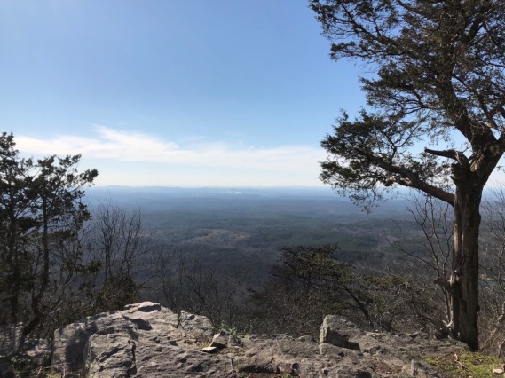
Our reward! I’m on the highest point in Alabama!
Oh my, I couldn’t hardly contain myself as soon as Bill took the picture. I shouted, I found our reward! Granted, it wasn’t the clearest day, but was better than others wrote about in their trail reviews. It was well worth it. But we still had two miles left back to the trailhead and our car. The trail “settled” down a little bit after this next rocky outcrop, two pictures below.

It was so funny, I was taking a picture of Bill walking, he suddenly turned and took the next picture of me!

The trail begins to “settle” as you can see in the above picture. This one of me was the last of the rocky outcrops.
Soon after this, we met up with two hiker/campers. They were just starting out and planned to overnight camp. They told us only a mile to the trailhead. But first, we had another fabulous view of Alabama!
Nearly an hour later, we came to this outcrop!

We had never heard of this trail that connects to the Appalachian Trail!

We had never heard of this extension to the Appalachian Trail. How exciting to “stumble” onto it. Click on the picture to be taken to the website for more information.
The Pinhoti National Recreation Trail / Millennium Legacy Trail is a premier southern Appalachian long distance hiking trail and it is also a southeast region Appalachian Trail connector. The total distance of the trail is 337.1 miles. There are 170.7 miles in Alabama and 166.4 miles in Georgia, which makes the Pinhoti the longest hiking trail in either state.” From the official website.
We missed this little sign, otherwise, we would have started on the Pinhoti Trail, the “difficult” one! Good thing but because it was so hidden, it made Bill question that the two trails met at the same trailhead where we parked.
From my All Trails which captured this hike. The red dots were where I stopped and added a picture to the app.


What an accomplishment, over 7 1/2 miles, with an elevation of 1,240 and moving (not counting the stopping for lunch and photos) was 4 1/2 hours. My Apple Watch app showed a slight variation, it said we went 7.68 miles and were out there for 5 1/2 hours (includes when we aren’t moving) and showed 1,509 elevation. Wonder why the differences? No matter, we’ve said that was two days worth of hikes. So no need to come back the next day to hike the Pinhoti! We were glad we did it the way we went.
The next day, took care of household matters, laundry, grocery shopping and recovering! We really hadn’t had a “day off” for weeks where we could take care of the routines of life. Usually we squeeze them in between our exciting days of hiking, remodeling, driving to see family, etc.
Since we had such an aggressive hike, our next adventure was a bit tamer. We visited the “Anniston Museum of Natural History” which also had a nature trail. It was a wonderful museum and a place we would love to bring our grandsons. It’s a teachers dream, we are sure. Very educational. The nature trail was a pleasant way to end our day.

On Sunday, we visited the The First Baptist Church of Oxford. It was a wonderful fellowship and an excellent but unusual service for Palm Sunday. The pastor stepped aside to let the new Pastor of the Student Ministry preach. It was great to see such a huge group of young people attending church. It was a service we will remember for a long time!
Sadly, our time was over and time to make the final trek back up to Virginia for a month. We decided we would definitely return as we only scratched the surface in the Anniston – Oxford area. It wasn’t the Smokies but it was a worthwhile side trip!
Our next stop was back to Cummins Sales and Service, Spartanburg, SC, to have our diesel and generator serviced. We simply drove there and spent the night. Tiffany went in for service at 8:00 am and by 11:30 am, we were back on the road! We can’t say enough about how excellent the service is here.
We were just over 400 miles from our destination, Fredericksburg, Virginia. Bill found Jones Station RV Park and Campground, Mebane, NC to be a good half way point. We found a hidden gem and decided this is a place we will re-visit for a few more days. We managed two more great hikes and discovered a nice big rig friendly campground, although a bit more than we like to pay ($35 with Good Sam Discount). I forgot to take a picture of our site….so I’ll hold off on any more about the area until another time.
We arrived back in Fredericksburg for Easter and into the open arms of our grandsons. Our son-in-law actually greeted us first and our daughter hugged us like she really loved us (we never doubt it but it was a rough winter). We hope and pray every one had a blessed Easter!


I was glad to see you at my place today, so I was on the look out to see what you were up to. Oh my, all I can say about all your hiking, climbing, and other physical stuff, is that it must be great fun to eat all you want and know you not storing it! I got a chuckle out of your “easy” trail. 😀
LikeLiked by 1 person
Nice to hear from you! We’re loving it and hope to keep it up as long as possible! But I can tell you we certainly are not doing all we want – we are eating less than we ever have! It is amazing how as we grow older. We have really had to adjust our eating habits, but it is paying off in dividends. I’m so excited my knees are not bothering me anymore, and my husband is glad his quit creaking!!! Lol
LikeLiked by 1 person
Wow you guys are amazing! I love reading your adventures, they are fun and educational. Thanks for sharing.
LikeLiked by 2 people
Awww, thanks Mary!!! We’re so grateful we can still do it! The only way to keep it up is to keep on climbing-but it’s not easy to do because of weather. So we over do it when we can! Lol
Are you on the road yet?
LikeLiked by 2 people
Reblogged this on Dream Big, Dream Often.
LikeLiked by 2 people
How kind! Thank you! Now maybe I will catch up with my blogging. I’m only two months behind! 😁
LikeLiked by 3 people
Beautiful Family Sister in Christ-Messiah Jesus-Yeshua Debbie!!
I Love you all Everyone through Jesus-Yeshua Christ, because HE LOVED 💜💕 EVERYONE FIRST!!
Love 💕 Always and Shalom ( Peace ), YSIC \o/
Kristi Ann
LikeLiked by 3 people
Thank you!!! We are so grateful and feel so blessed! Love 💕 sweet Kristi Ann!
LikeLiked by 1 person